Hobart sits on a mix of Permian mudstone, Triassic sandstone, and Quaternary alluvial deposits along the Derwent Estuary. The soft estuarine silts and variable fill layers in areas like Sullivans Cove can amplify ground motion during earthquakes. A MASW survey measures shear wave velocity (Vs) to a depth of 30 m, yielding the VS30 value used for seismic site classification under AS/NZS 1170. This non-invasive method avoids borehole drilling and provides a continuous 1D or 2D profile of soil stiffness. For projects requiring complementary data, the team often pairs MASW with a dilatometer test to assess lateral stress in deeper layers.
A single MASW line can replace three or four boreholes for seismic site classification—saving time and reducing invasive ground work.
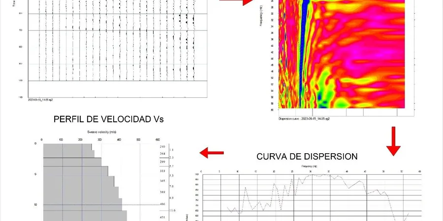
Methodology and scope
- VS30 value for seismic site class (A–E per AS 1170.4)
- 1D Vs profile with depth
- Poisson's ratio estimate from P-wave data
- Soil stiffness map for foundation design
Local considerations
A common oversight in Hobart is assuming that all sites with shallow rock fall into seismic class A (rock sites). The weathered mudstone cap can lower Vs below 760 m/s, pushing the site into class B or even C. Without a MASW survey, designers may underestimate the design response spectrum and under-size foundations. In the 1989 Newcastle earthquake, sites classified as rock but underlain by weathered sediments suffered disproportionate damage. Getting the VS30 right from the start avoids costly retrofits.
Applicable standards
AS 1289, AS/NZS 1170.4:2007 (Amdt 2), NEHRP Recommended Seismic Provisions (FEMA P-1050)
Associated technical services
Standard MASW / VS30 Survey
Linear array with 24 geophones, 46 m spread, sledgehammer source. Output: 1D Vs profile to 30 m depth and VS30 value. Ideal for single-building seismic classification.
2D MASW Cross-Section
Multiple overlapping MASW lines to produce a continuous 2D shear wave velocity section. Used for large sites, road corridors, or embankment assessments.
ReMi (Refraction Microtremor)
Passive surface-wave method using ambient noise. Useful in urban areas of Hobart where active sources are restricted. Depth range 10–50 m.
MASW with HVSR Validation
Combined active MASW and single-station HVSR microtremor measurement. HVSR provides the fundamental site period (T0) which cross-checks the Vs profile.
Typical parameters
Frequently asked questions
How does MASW differ from a standard SPT borehole for VS30?
MASW measures shear wave velocity directly from surface waves, covering a large area in a single day without drilling. SPT boreholes give Vs from empirical correlations at discrete depths and are more invasive. MASW is preferred for seismic site classification because it provides a continuous profile, while SPT is better for strength parameters.
What VS30 values are typical for Hobart's geology?
In the city center on alluvial terraces, VS30 ranges from 250 to 400 m/s (site class D–C). On the foothills of Mount Wellington, weathered mudstone yields VS30 of 500–700 m/s (class C–B). Reclaimed areas near the waterfront can drop below 200 m/s (class E).
What is the cost range for a MASW survey in Hobart?
The typical cost for a standard MASW / VS30 survey in Hobart is between AU$2,550 and AU$4,240, depending on array length, number of lines, and site access. This is generally lower than the cost of three SPT boreholes for the same classification.
Can MASW be performed on steep slopes or rocky ground?
Yes, the method works on slopes up to about 30 degrees as long as a linear array can be laid out. On very rocky terrain, the geophone coupling may be improved with plaster or quick-set grout. For extremely steep sites, passive ReMi is a better option.